บทความ

13.10.2560 KACHIN NATIONAL MANAU PARK in Myitkyina, Northern Myanmar/Burma. สาธารณรัฐแห่งสหภาพเมียนมาร์.

รูปภาพ
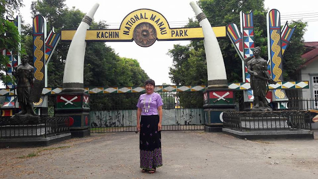
01.ขอบคุณ ภาพและข้อมูล จาก Ma Thandar    01. Kachin National Manau Park in Myitkyina, Northern Myanmar/Burma KACHIN NATIONAL MANAU PARK สาธารณรัฐแห่งสหภาพเมียนมาร์.  02. Kachin National Manau Park in Myitkyina, Northern Myanmar/Burma KACHIN NATIONAL MANAU PARK สาธารณรัฐแห่งสหภาพเมียนมาร์.  03. 04. The Rhythm of Myanmar. 13.10.2017

22.04.2561 Kachin State (Kachin: Jingphaw Mungdaw) is the northernmost state of Myanmar.

รูปภาพ
Kachin State From Wikipedia, the free encyclopedia Kachin State ကခ်င္ျပည္နယ္ Wunpawng Mungdan State Flag Location of Kachin State in Myanmar Coordinates:  26°0′N   97°30′E Coordinates :  26°0′N   97°30′E Country   Myanmar Region Northern Capital Myitkyina Government  • Chief Minister Khat Aung  ( NLD )  • Cabinet Kachin State Government  • Legislature Kachin State Hluttaw  •  High Court Kachin State High Court Area  • Total 89,041.8 km 2  (34,379.2 sq mi) Area rank 3rd Population  ( 2014 ) [1]  • Total 1,689,441  • Rank 10th  • Density 19/km 2  (49/sq mi) Demographics  • Ethnicities Kachin  (includ.  Zaiwa ),  Lisu ,  Han-Chinese ,  Shan ,  Naga ,  Bamar ,  Nu ,  Tibetan  • Religions Theravada Buddhism  64.0% Christianity  33.8% Islam  1.6% Hinduism Mahayana Buddhism Animism 0.2% Time zone MST  ( UTC+06:30 ) Kachin State  ( Kachin : Jingphaw Mungdaw;  Burmese :  ကခ်င္ျပည္နယ္ ) is the northernmost  state  of  Myanmar . It is bordered by  China  t